
File:Chesapeake and Ohio Canal National Historical Park (map).jpg

預覽大小:226 × 598 像素。 其他解析度:90 × 240 像素 | 181 × 480 像素 | 290 × 768 像素 | 387 × 1,024 像素 | 774 × 2,048 像素 | 2,740 × 7,248 像素。
原始檔案 (2,740 × 7,248 像素,檔案大小:6.8 MB,MIME 類型:image/jpeg)
.jpg)
檔案歷史
點選日期/時間以檢視該時間的檔案版本。
| 日期/時間 | 縮圖 | 尺寸 | 使用者 | 備註 | |
|---|---|---|---|---|---|
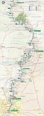
| 目前 | 2007年2月6日 (二) 15:38 | 2,740 × 7,248(6.8 MB) | Daderot | {{Information |Description=Map of the Chesapeake and Ohio Canal National Historical Park, along the former Chesapeake and Ohio Canal between Cumberland, Maryland, and Washington, D.C., USA. |Source=United States National Park Service, website for Chesapea |
檔案用途
下列頁面有用到此檔案:
全域檔案使用狀況
以下其他 wiki 使用了這個檔案:
- da.wikipedia.org 的使用狀況
- de.wikipedia.org 的使用狀況
- enbaike.710302.xyz 的使用狀況
- fr.wikipedia.org 的使用狀況
- no.wikipedia.org 的使用狀況
- pl.wikipedia.org 的使用狀況
.jpg)